
Dresden to Prague via Saxon Switzerland: The Detour Worth Making
Between Dresden and Prague there is a stretch of national park that most people drive straight past. The Bastei Bridge sits 194 metres above the Elbe River and takes roughly two hours to visit. It is not a complicated detour. It is, however, one of the better decisions you can make on a Central Europe road trip.
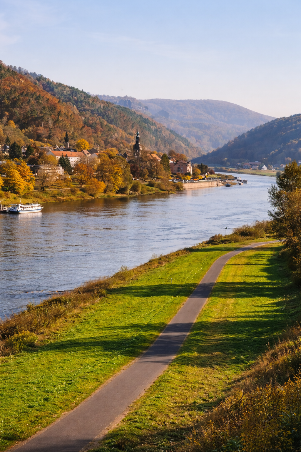
The Dresden to Prague drive takes around an hour and a half by motorway — direct, efficient, and entirely unremarkable. We did not take the motorway. Instead, we parked the car near Pirna Bahnhof, walked to the river, took the small ferry across the Elbe, and spent the next two hours climbing up through sandstone forest to one of the stranger and more beautiful things in this part of Europe.
A landscape that belongs to no particular category
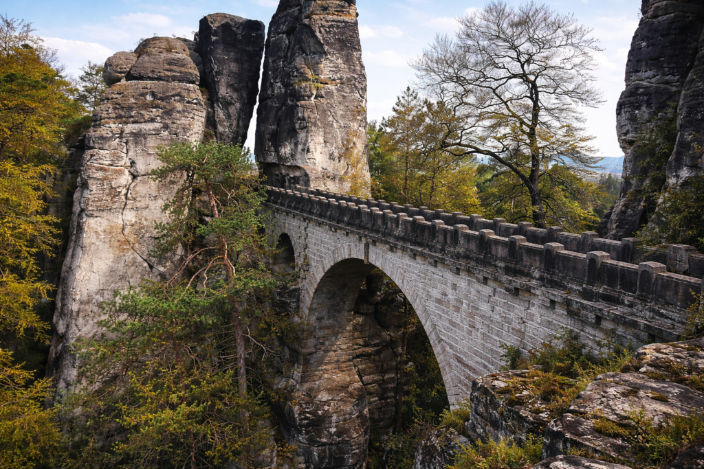
Saxon Switzerland is a misleading name. The national park sits in the German state of Saxony, about 40 kilometres southeast of Dresden, and has nothing to do with Switzerland beyond the fact that Swiss painters working in Dresden in the 18th century thought the landscape reminded them of home. What they were looking at was the Elbe Sandstone Mountains — a landscape of vertical rock formations, narrow gorges, forested plateaus, and table mountains that rises abruptly from the river valley and belongs to no particular category you will have encountered before. The Bastei is its most famous point. The bridge that connects two of the sandstone towers has been drawing visitors since 1824, when a wooden version was first built here as a tourist attraction. The stone version that replaced it in 1851 is still standing.
This post covers both ways to reach it, what you find when you get there, and everything else worth knowing about the detour.
01 — Two Ways to Get There
There is a meaningful choice to make before you arrive at Saxon Switzerland, and it determines the quality of the experience considerably. You can drive straight to the car park near the top and walk a short distance to the bridge. Or you can park near Pirna, take the train or drive to the river crossing at Rathen, cross the Elbe by ferry, and hike up through the national park on foot. Both end at the same bridge. They are not, however, the same experience.
Option A — Drive to the top (the quick version)
If time is short or the group is not up for a hike, the car park on the plateau above the Bastei puts you within a short flat walk of the bridge. From there, it is perhaps ten minutes on foot along a well-maintained path to the viewpoints and the bridge itself. The landscape is still extraordinary — you are arriving at 305 metres above sea level into a forest of sandstone pillars and gnarled pines, and the views from the bridge are the same regardless of how you got there. This is a reasonable option if you have an hour rather than two, or if you are travelling with people for whom a steep hike is not practical.
The drive to the car park from Dresden takes around 45 minutes. From the car park, follow the signs to the Basteibrücke — it is a short, flat walk that most people manage in ten to fifteen minutes. In summer the car park fills early; arriving before 10am avoids the worst of it.
Option B — Boat and hike (the better version)
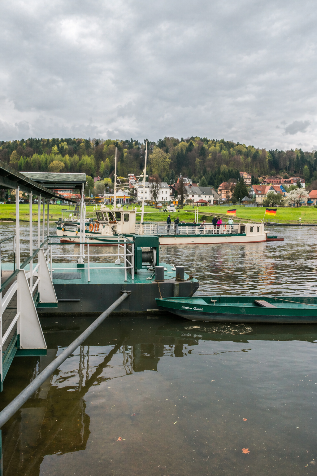
Park near Pirna Bahnhof and drive or take the S-Bahn train to Kurort Rathen — a small, car-free spa village that sits directly at the foot of the Bastei cliffs on the eastern bank of the Elbe. From Rathen station, the Rathen Ferry terminal is a five-minute walk. The ferry itself is a standing boat that crosses the river in a matter of minutes, runs every ten minutes throughout the day, and costs €2 return. It is a protected monument — the same ferry crossing, in one form or another, has operated here for centuries.
Arriving at Rathen
On the far bank, the village of Rathen receives you quietly: colourful spa-era houses, fish restaurants along the water, and immediately ahead, the forested cliff face rising to the Bastei above. The hiking trail begins at the edge of the village and goes up from there.
We parked near Pirna and took the boat route. The hike up is genuinely part of the experience — the forest, the rock formations visible through the trees on the way up, and the moment the landscape opens onto the bridge are things the car option simply skips. If you have two hours to spare on the Dresden to Prague drive, take the boat.
02 — The Hike from the Elbe
From the village of Rathen, the trail up to the Bastei is well-marked and takes between 30 and 40 minutes at a comfortable pace. The total elevation gain is around 200 metres — the equivalent of climbing a 20-storey building — concentrated into a trail that alternates between forested paths, steep stone steps, and occasional wooden railings on the more exposed sections. Hiking boots are not required, but shoes with some grip are sensible. The trail is maintained to a high standard throughout.
What the climb is like
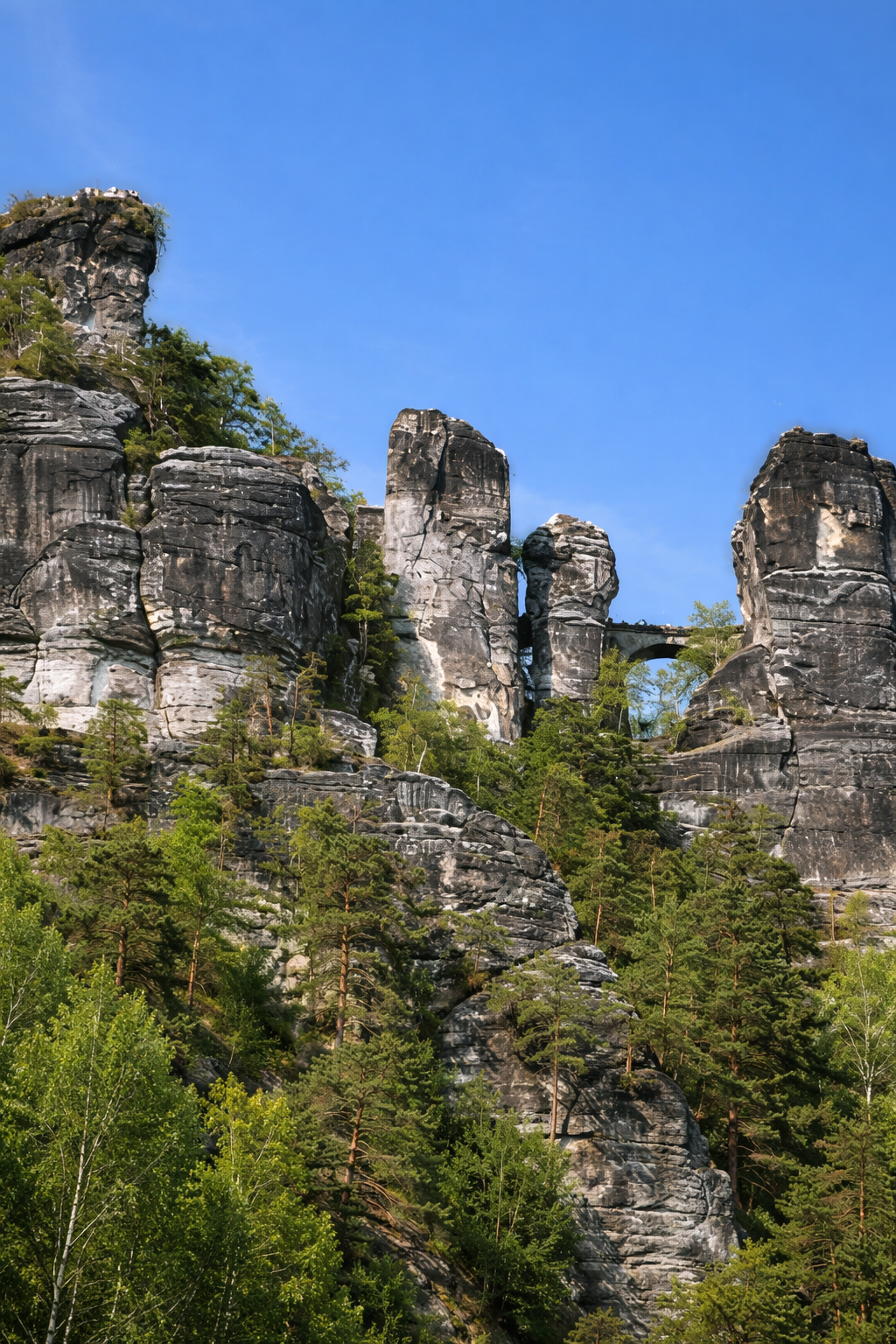
The lower section runs through forest — tall pines and sandstone boulders emerging between the trees, the Elbe still visible below through gaps in the canopy. As the trail climbs, the rock formations become more present: pillars and walls of sandstone that have been shaped by water erosion over a million years into shapes that are too specific to feel entirely random. Some of them have names. Some are used by climbers — Saxon Switzerland is one of Germany’s most significant climbing areas, and the vertical faces above the forest are scored with routes that have been established over more than a century.
On the way up, the trail passes a small open-air museum dedicated to the Slavic settlement of the region — easy to walk past without noticing, worth pausing at briefly. Further up, a path branches off toward the Felsenbühne Rathen, the open-air theatre built into a natural hollow in the cliff face. If you are visiting between May and October, it is worth checking whether a performance is scheduled — the theatre stages opera, operetta, and plays against a backdrop of sandstone cliffs that no purpose-built venue could replicate.
The final approach
The top of the climb arrives without ceremony. The forest thins, the path levels out, and suddenly you are on the plateau — surrounded by sandstone towers, the river invisible far below, and the bridge visible across a narrow gap in the rock. Additionally, the Schwedenlöcher, a moss-covered gorge named for the local population who sheltered there during the Thirty Years War, branches off nearby as an alternative descent route if you want to vary the return journey. It is cool even in summer and is one of the quieter corners of the area.
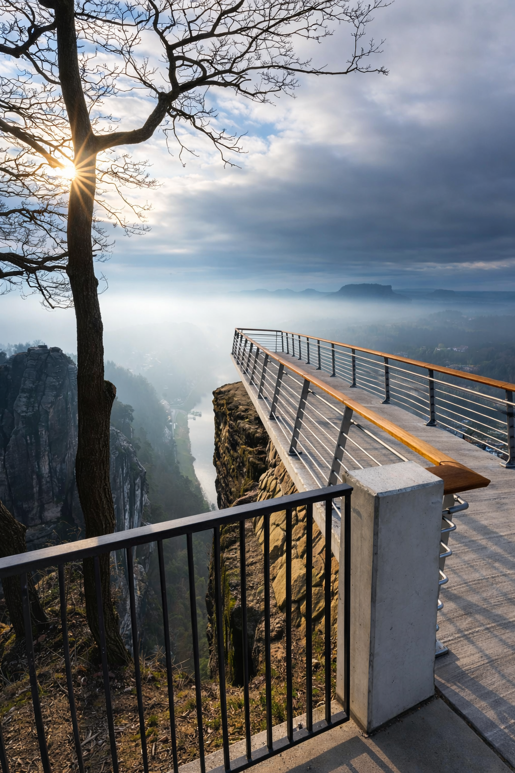
03 — The Bastei Bridge
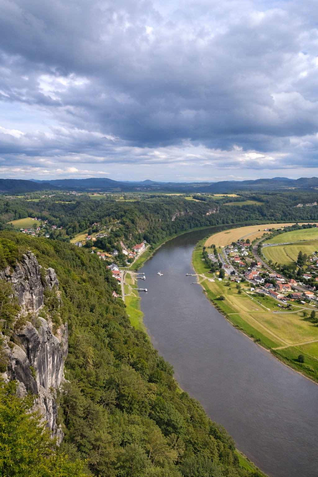
The bridge is 76 metres long and spans a narrow gap — the Mardertelle — between several sandstone rock towers. It was built in 1851 to replace a wooden predecessor, and it connects the main viewpoint platform to the ruins of Neurathen Castle on the far side. Standing on it, the river is not visible directly below — the drop is too sheer and the rock formations block the straight-down view — but the Elbe valley opens wide on both sides, and on a clear day the table mountains of Lilienstein and Königstein are visible across the valley.
The view and the feeling of it
The landscape from the bridge is the kind that is genuinely difficult to photograph because the photograph inevitably flattens it. What the bridge gives you is scale that requires you to be standing on it: the rock towers rising above you, the valley falling away below, the forested plateau stretching in all directions, and the sense that this particular corner of Saxony has been shaped by geological processes that have nothing to do with anything human. In that respect it has more in common with the landscapes of the American Southwest than with the Central European cityscape you drove through to get here.
When we visited, it was not crowded — a handful of other hikers, no coach groups at the viewpoint. The midday hour is the busiest; arriving in the morning or late afternoon, as we did, gives you the place at something close to its best.
Neurathen Castle
Across the bridge, the ruins of Neurathen Castle occupy the rock on the far side. This was once the largest rock castle in Saxon Switzerland — rooms and passageways carved directly into the sandstone, a cistern, and the rebates where timber structures once connected the carved sections into a functioning fortress. What remains today is an open-air museum of those carved elements: hollows in the rock that require some imagination to reconstruct but reward it. The castle is usually accessible for a small entry fee; check current opening status before visiting as it has been subject to periodic closures for restoration.
04 — Also Worth Seeing in the Area
The Bastei is the primary draw, but the area around Rathen and the broader Saxon Switzerland park contains enough to occupy a longer visit if time allows. For a road trip detour with two hours budgeted, the bridge and the hike are sufficient. However, if you have the morning free before continuing toward Prague, the following are worth knowing about.
If you have more than two hours
Described as Europe’s most scenic natural theatre, the Felsenbühne is built into a hollow in the sandstone cliffs above Rathen. Opera, operetta, plays, and Karl May pieces (the wildly popular German Western stories set in the American frontier) are staged here from May to October against a backdrop of rock that no architect could improve on. Worth checking the programme before you visit — performances run in the evening and the setting alone justifies attending something.
The largest rock castle in Saxon Switzerland, reached by crossing the Bastei Bridge. Rooms, passageways, a cistern, and medieval stonework are carved directly into the sandstone. The views back toward the bridge from the castle side are some of the best in the area. Check current access before visiting — the castle has been subject to closures for restoration work.
A narrow, moss-covered gorge near the Bastei plateau, named for the local population who hid here during the Thirty Years War. Cool even in summer, quiet, and a good alternative to the main trail for the descent. Adds perhaps 20 minutes to the return journey and gives a completely different character to the walk back.
Further afield
A massive hilltop fortress visible from the Bastei viewpoint as a flat-topped rock rising from the valley floor about 10 kilometres downriver. One of the largest mountain fortresses in Europe, with a history stretching from the 13th century through to its use as a prisoner-of-war camp in both World Wars. Worth a visit in its own right if you have an extra two hours — it is a short drive from the Bastei area.
The Elbe is navigable here and served by a fleet of historic paddle steamers that have been running since the 19th century. The boat from Dresden stops at Rathen and continues to Königstein and Bad Schandau — a slower and considerably more scenic alternative to the train if you have the afternoon. The Bastei Bridge is visible from the river as the boat passes.
The village of Rathen on the far bank has a handful of fish restaurants along the waterfront that make a good lunch stop after the descent. The village is car-free, quiet, and has the specific atmosphere of a spa resort that has been receiving walkers and climbers for over a century. Sitting by the Elbe after the hike, waiting for the ferry back, is a good use of whatever time remains.
05 — Onward to Prague
From the Bastei area, Prague is roughly an hour and 45 minutes by car — depending on how long the border crossing at the Czech frontier takes, which varies. The route follows the Elbe valley south from Pirna, through the narrow canyon where the river cuts between German and Czech territory, and into Bohemia. It is one of the more scenic road approaches to Prague from the north: the Elbe valley here is steep-sided and forested, and for a stretch the landscape has the character of the national park on both sides of the border.
What the drive looks like
After Pirna, the B172 runs southeast along the river through Bad Schandau — the last significant town before the Czech border, and a pleasant stop if you need fuel or food. The crossing itself is generally straightforward for EU and Schengen passport holders; non-EU travellers should check current entry requirements for the Czech Republic before leaving Germany. Beyond the border, the road follows the river as it widens gradually into the Bohemian countryside, and Prague arrives after another hour of driving through a landscape that becomes progressively less dramatic and more agricultural as you approach the city.
We arrived in Prague in the early afternoon — enough time to check in, walk to the river, and begin the process of reorienting to a new city. That transition from national park to capital in under two hours is one of the more satisfying aspects of this particular stretch of the Central Europe road trip. The detour costs you two hours. In exchange, it gives you one of the more memorable things on the route.
The Czech Republic requires a motorway vignette for driving on its highways. An e-vignette can be purchased online before you travel — the 10-day version costs around €14 and is the most practical option for a road trip passing through. Without it, you risk a fine at the border or at a checkpoint. Buy it the day before you leave Dresden.
06 — Practical Notes
Getting There and On the Ground
| Getting to Rathen by car | Park near Pirna Bahnhof (paid parking, usually available) and take the S1 S-Bahn train to Kurort Rathen — a 20-minute ride. Alternatively, drive directly to the Bastei car park on the plateau: take the A17 from Dresden, exit at Pirna-Copitz, then follow the B172 and signs to Bastei. Car park fills quickly in summer — arrive before 10am. |
| The Rathen Ferry | The F7 ferry crosses the Elbe between Niederrathen and Rathen. Runs every 10 minutes throughout the day. One-way ticket €1.20 adult; return ticket €2.00. Cash preferred. The ferry is a standing boat — crossing takes around 3 minutes. |
| The hike | 2.6 miles (4.2km) out-and-back from Rathen to the Bastei Bridge. Elevation gain: approximately 200 metres. Time: 30–40 minutes up, 25–35 minutes back, plus time at the bridge. Total loop: 1.5–2 hours. No hiking boots required but grip shoes recommended. The trail is well-marked throughout. |
| Entry costs | National park entry is free. The Bastei Bridge is free. Neurathen Castle charges a small entry fee (a few euros). The car park on the plateau charges for parking. |
When to Go and Moving On
| Crowds | Midday is the busiest period, particularly in summer. Morning arrival (before 10am) or late afternoon gives a noticeably quieter experience. Weekdays are quieter than weekends year-round. |
| Best season | February through November. Summer is warm but busy; spring and autumn offer better light and fewer people. The trail is open year-round but winter conditions can make the steps icy. |
| Onward to Prague | From the Bastei area: approximately 1h45 to Prague city centre by car. Follow B172 south through Bad Schandau to the Czech border, then follow signs for Prague (Praha). Czech Republic motorway vignette required — buy online before travel. |
Planning Your Visit
Good to Know
We were back at the car by early afternoon, the bridge already two hours behind us and Prague still ahead.
The detour added nothing to the overall distance and perhaps ninety minutes to the day. What it added to the trip is harder to quantify — but that is true of most things worth doing on a road through Central Europe.